2020 has been an extraordinary year for many reasons already, and let’s hope things don’t continue to be so disruptive! In terms of climate we had the wettest February on record (ie since 1862) shortly followed by the sunniest April on record. Extreme weather events like these are happening more and more frequently and have been predicted by the climate models developed by scientists over recent decades. There is now no doubt that climate change is accelerating in response to increasing greenhouse gas emissions. A climate emergency has been declared at national and local level and there is hope that we are, at last, treating this crisis with the seriousness it deserves.
One of the key aspects of climate change is that we are already locked in to a considerable amount of warming. The graphic below shows that even if we manage to change our ways and reduce greenhouse gas emissions sharply, the gases we have already emitted will stay in the atmosphere for many years and the planet will continue to warm. That means extreme weather events are likely for the foreseeable future and are also forecast to become more intense and more frequent. As a result, it’s estimated that, if we don’t take action, by the year 2100 the cost of flooding in Devon will amount to £1bn per year (download full report here).

This graphic comes from the Climate Action Tracker website.
The Connecting the Culm project is focused mainly on helping residents and organisations in the Culm catchment adapt to the inevitable changes that will come from extreme rainfall events and extreme drought events. By working with nature, we can help the river become less likely to flood and less likely to dry out – and at the same time improve it for people and wildlife. What’s more, it’s a very cost-effective way of achieving these benefits.
How will the River Culm be affected?
At the start of the Connecting the Culm project we developed a computer model of the Culm catchment that we can use to forecast a range of scenarios. We can enter different rainfall scenarios and also model changes in land use (as described on our Working with Nature page) to absorb or retain more or less water. The model has proved to be accurate – we know this because we tested it against the actual flood event of 2012, which saw the main railway line to the Westcountry closed at Hele, and the model matched the actual data very closely. This means we now have confidence in using it to forecast future events.

Output from our computer model showing the 2012 flooding at Hele. The red outline is the actual flood level that occurred and the blue shading is the model’s prediction, based on the rainfall record.
Using the model and working with colleagues in the Environment Agency, Devon County Council, Mid-Devon District Council and elsewhere, we are now developing more detailed forecasts based around different scenarios. These will be fed into the Blueprint development process, so that we can visualise the impacts of different land and water management decisions.
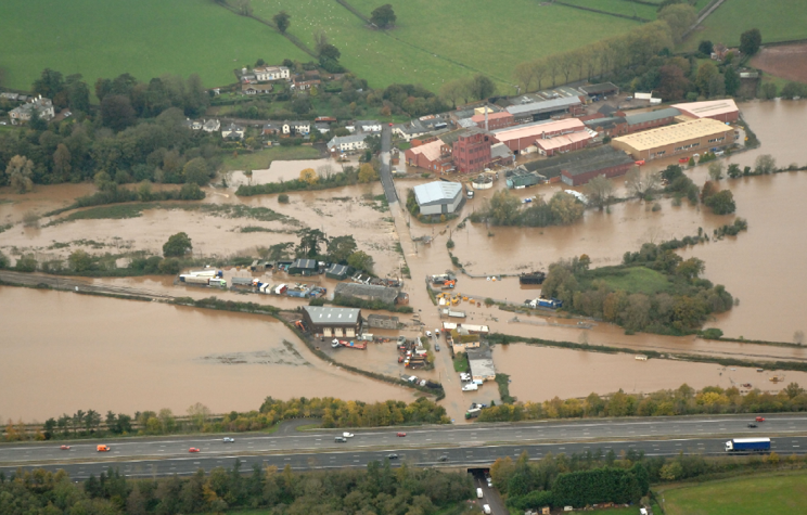
The 2012 flooding at Hele that closed the railway


Leave A Comment