A summary of our research and the outcomes of consultation – June 2020 – June 2021
Over the past year we’ve been researching, exploring, discussing and consulting with multiple agencies, organisations and individuals across the catchment of the River Culm. The following pages summarise what we discovered. Much of the data is captured in our Environmental Evidence Review.
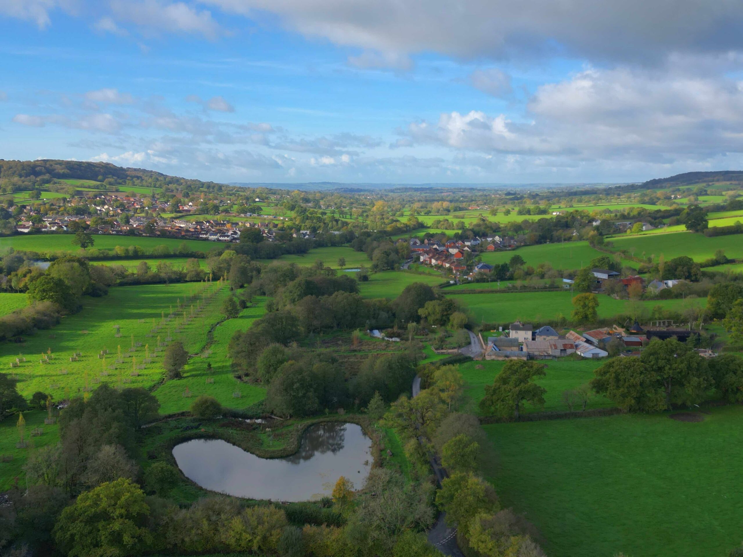
The River Culm runs from its source at Culmhead in the Blackdown Hills to join the River Exe just north of Exeter. In total the Culm and its tributaries drain 100 square miles of South Somerset, and Mid and East Devon, 87% of which is agricultural land, 9% woodland and 4% the built environment.
Approximately 30,000 people live in the catchment, many of these in the main town of Cullompton. Properties in the catchment are at risk of flooding from rainfall and the river bursting its banks, and further properties and infrastructure in Exeter are also affected by the Culm, after its waters combine with the River Exe.
The main railway line to the South-West and the M5 motorway both run alongside the river through the floodplain for many miles and are both subject to flooding, cutting off two of the peninsula’s key transport arteries (Fig 1).
Climate change is already generating weather events of increasing intensity and, on our current trajectory of greenhouse gas emissions, these events are set to get more frequent and more intense. In the past we have built ever higher flood defences but the costs of doing so are very high – for example, Exeter’s Flood Defence Scheme (2014 – 20) cost £32m. As a society we need to both adapt to the changes that are already happening and reduce our greenhouse gas emissions so that future climate change is less damaging.
Connecting the Culm is focused on working with nature and people to adapt to the increased risk of flooding and drought that is expected due to climate change. We are bringing together people and organisations from across the catchment to share knowledge and resources and develop a long-term plan that coordinates people and organisation’s plans, investments, and actions, giving us the best chance of successfully adapting to an uncertain future.
Part 1: The Fundamentals of the Culm Catchment
1.1 Soils
How well our soils absorb water is the single most important factor we can influence in determining how much flood and drought we experience. When rain falls on a naturally well-draining soil, much of it can be absorbed and will gradually percolate down to replenish the water table deep underground. When it falls on a compacted soil it tends to run quickly over the surface, eroding soil particles and carrying them into the nearest stream, often then causing flooding and excessive silting downstream.
Different soil types have different characteristics and vulnerabilities. In the Culm catchment, some sandy soils in the lower catchment are used for arable crops and are at risk of erosion; and some heavy soils are at risk of compaction caused by livestock and by the use of heavy machinery at the wrong time of year, often associated with harvesting crops such as maize and applying manures or spreading slurry in the autumn/winter. These practices are often associated with modern dairy farming in the Culm catchment.
On the Upper Culm plateau a layer of clay-with-flint sits under generally shallow soils. These soils can very easily become compacted and, if this occurs, they generate significant runoff during rainfall, causing localised flooding, erosion of the greensand valleys below and pollution (see Fig 3).
Running beneath the clay capped plateau is a layer of permeable Greensand rock with permeable brown earth soils overlaying it. Water percolates through these soils and provides the base flow for many of the small streams feeding the River Culm, via the spring-line mires. These are features occurring on the surface of the hillsides, where the greensand meets the less permeable clay beneath, and water emerges onto the hillside. Recharge of the aquifer through the clay-with-flint is very slow but is key to restoring more normal flows, where flow generated by rainfall is released over months rather than minutes.
The lower catchment consists mainly of slowly-draining soils overlying Permian mudstones and Triassic sandstone. There are more arable crops grown in this area of the catchment, with evidence of significant soil erosion and loss in some areas, as well as livestock farming on grassland where soils are vulnerable to damage through compaction.
In the river valleys we find alluvial soils that are naturally well-drained and fertile, with some wetter backlands. Historically these would be species rich hay and grazing meadows with a network of drained springs and historic channels, although many of these have been lost over the years.
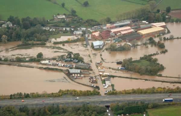
Fig 1: flooding of the railway line Hele in 2012
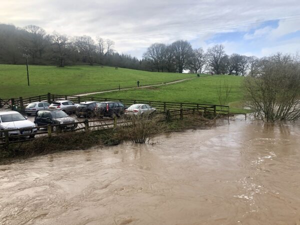
Fig 2: Flooding on the Culm at Killerton
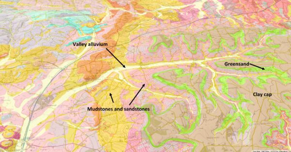
Fig 3: Soil map of the upper Culm, showing the clay cap on the upper plateau. From the British Geological Survey.
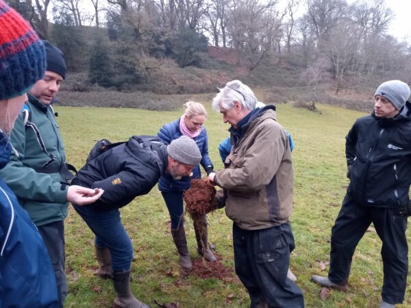
Fig 4: Getting close and personal with soils, under the guidance of the Environment Agency's Richard Smith
1.2 Water Quality
As outlined above, excessive water run-off from farmland can erode soils, transporting soil particles into rivers. These particles damage water quality and the river ecosystem, partly by making the water cloudy and attaching to the leaves of aquatic plants (both of which restrict sunlight reaching the plants – see Fig 5); partly by depositing on river gravels where they harm their use by fish as spawning grounds; and partly because these particles can also transport pollutants like phosphates into the river. Phosphates are a serious concern because they stimulate algal growth and these “algal blooms” can starve the river and many of its species of essential oxygen. Nitrate pollution from farmland is also a concern.
Phosphates can also get into the river from sewage treatment works and septic tanks so it is important that these are functioning properly. Combined sewer overflows (CSOs), a legacy of older sewage systems which combine rain water and domestic waste water in a single pipe, can also allow pollution into the river when there is high rainfall.
However, the evidence from our research is that the main source of phosphate pollution in the Culm is farmland, as shown on Fig 6.
1.3 Human impacts on the landscape
For at least 4000 years humans have been changing the natural landscape in the Culm, shaping it to our purposes: adapting vegetation to feed, clothe and house ourselves, and changing the flow of water through the landscape to harness its energy. The river valleys would have been some of the earliest landscapes to be changed, as they offered plentiful food sources and fertile soils. Trees were cleared and fields established as agricultural techniques developed. By Roman times the landscape consisted of a patchwork of small fields bounded by hedges with plentiful copses and larger areas of woodland on higher ground.
For many centuries the river was the main energy source for the economy, driving waterwheels that ground flour, beat iron and made paper in turn as technology advanced. Channels were dug and weirs built to divert the river through the mills and so an already complex system of watercourses became even more diverse. Many of these mills and the watercourses that fed them have fallen into disuse, although the original buildings have been adapted to modern uses – as with Coldharbour Mill pictured in Fig 7.
During the last 100 years, as agricultural intensification has gathered speed, the landscape has changed again, more quickly. Field sizes have increased and hedgerows have been removed, most remaining hedgerows are kept tightly trimmed, ever-larger and more powerful machinery is used, maize is grown widely to sustain large dairy herds and feed bio-digesters, and the manure produced by over-wintering herds of cattle has to be stored carefully to avoid pollution escaping into the rivers. On the clay plateau traditional species-rich hay meadows and heathland have been made more agriculturally productive, with the loss of sensitive species such as curlew.
Our settlements have also expanded, with some development taking place on the floodplain where buildings are vulnerable to flooding. Transport links like the M5 and railway, built on the valley bottoms to avoid steep inclines, are also vulnerable. Flooding in these locations is a natural event, but has been made much more intense by land use changes upstream and by climate change.
1.4 Climate Change
Climate change is now possibly the greatest threat that humanity faces, a threat that over 97% of scientists agree has been created by our own actions. Greenhouse gas concentrations in the atmosphere have increased as a result of burning fossil fuels, changing land use including destroying so many of the world’s forests, and increasing livestock numbers to such a great extent. The effects are already being felt across the planet, with the average temperature now around 1oC higher than in 1900 – Fig 8.
An increase in the average temperature rise to 2oC now appears almost inevitable given the lack of progress made since the 2015 Paris Agreement, when this was set as the maximum level allowable. If current trends in emissions continue then the climate models show that we face even higher average temperature change – likely between 3°C and 4°C by the end of the century based on current policy and commitments – and consequently very severe impacts that will be difficult to adapt to at a global and local scale. This scenario – our current trajectory – will create massive disruption to our environment in Devon and intensifies the already challenging situation we face with disrupted natural processes, damaged soils, poor water quality and growing urbanisation.
The predictions for Devon are that we will face much hotter and drier summers, much wetter winters, and more intense rainfall at all times of year. These patterns mean that:
- Damaging heatwaves are likely to increase in frequency and duration
- the number of wildfire risk days will increase from 12 per year to 62 by the 2080s.
- Livestock will be at greater risk of thermal stress
- Drought conditions will damage water quality and biodiversity and also affect agriculture
- Winter rainfall, set to rise by up to 50%, increases flood risks
- Wetter weather could also lead to greater damage to soils as farmers try to manage their crops when soils are wet and subject to compaction and run-off.
You can read more on this subject in our article here: https://connectingtheculm.com/climate-change-and-its-likely-impacts-in-devon/
1.5 River profile
Flooding is a natural process and it is important to understand how a river responds to flood events in an entirely natural landscape. This can help us plan for a more resilient future that works more closely with nature.
Without human intervention, in a floodplain a river will create multiple generally quite shallow meanders and braided channels. A diverse wetland landscape is created with pools, ox-bow lakes, wet woodlands and wet meadows. When heavy rainfall occurs upstream, much of the water percolates down into the soil but some will find its way into watercourses. As the river swells, the water overtops these channels in the floodplain and spreads out across the surrounding land, dispersing the energy of the floodwaters.
In our crowded human-dominated landscape, over the centuries we have drained fields, dredged the river, dug out bankside trees and built banks to keep the river in its channel for as much of the time as possible. We have also compacted soils in the upper catchment so, when rain falls there, it runs very quickly into the river and creates a torrent of water. This torrent can’t disperse its energy by overtopping into the floodplain and so it carves a deeper channel and erodes the outer edge of river bends, eating into farmland (fig 9). Over time this carves out an “incised channel” with steep sides and unstable banks which also generates more soil load in the river. The water rushes faster down the catchment and, in the lower sections of the catchment where greater numbers of people live close to the river, in Cullompton, Stoke Canon and Exeter, the combined volume of water descending the river system can overtop defences and flooding can affect thousands of people.
We tend to see farmland in the floodplain flooded with water and see that as a problem (Fig 10). In fact, although this flooding can damage some types of crops, if farmers plan for it and protect livestock and farm infrastructure, it can have a relatively small effect on the farm – indeed floodplain grasslands can be fertilised by the sediments deposited by the floodwaters, and this was the basis for historic floodplain meadows which were the most valuable and fertile land before modern agricultural methods. The real problem occurs when flooding is generated by excessive runoff in the upper catchment, and diverted too quickly from the farmed floodplain downstream onto centres of population.
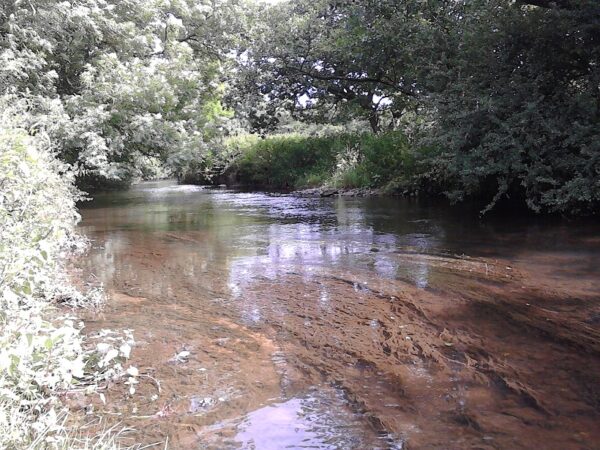
Fig 5: Water crowfoot heavily silted in the Culm
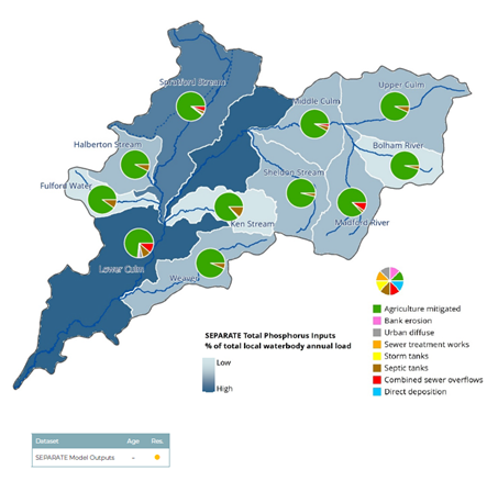
Fig 6: Origins of phosphorus in the waters of the Culm
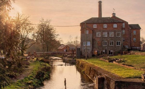
Fig 7: Coldharbour Mill, now a museum of mill life, by Alison Day
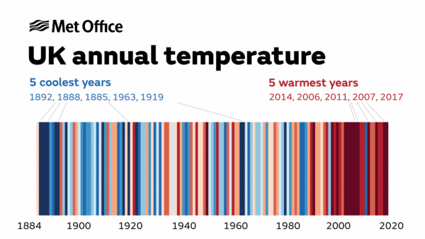
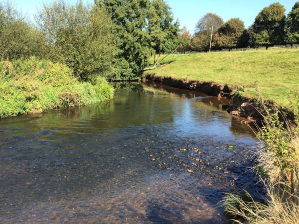
Fig 9: The Culm at Killerton showing a deeply incised river channel
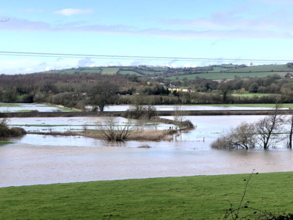
Fig 10: The Culm at Killerton in flood
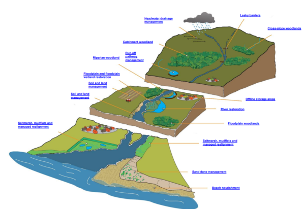
Fig 11: Image from the Environment Agency’s Evidence Base

Average Rainfall 1991-2010
Fig 12: Graph taken from the Soils Manual, published by the East Devon Catchment Partnership
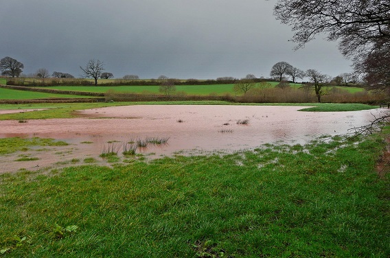
Fig 13: Flood-water storage using bunds, Holnicote Estate, Somerset (picture courtesy of the National Trust)
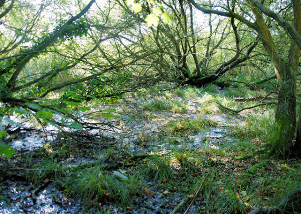
Fig 14: Typical wet woodland
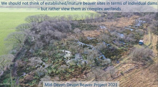
Fig 15: Aerial view of the impact of beavers. Picture credit Richard Brazier, University of Exeter
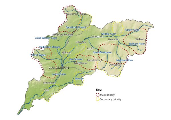
Fig 16: The Priority Areas for the project
Part 2: Nature-based Solutions
The challenges outlined above are complex and inter-linked. They have been growing in complexity and impact over many years and the activities that generate them have become embedded in many people’s way of life. For almost as many years we have, as a society, been trying to tackle these impacts, often by building higher flood defences, for example, or adding air conditioning to our homes. However, these approaches can be both expensive and inflexible. Our research shows that there is a range of more natural approaches that can help us adapt to climate change in the Culm catchment at the same time as making our landscape richer in wildlife and better for people.
Working with natural processes and “working with the grain of nature” is an approach that is now accepted as an essential part of our response to the climate and ecological emergencies. Nature-based solutions cover a wide range of options and you can find out more in the Environment Agency’s Evidence Base which details 14 different measures (see Fig 11) and provides 65 case studies. You can also read a quick summary elsewhere on this website: https://connectingtheculm.com/what-are-nature-based-solutions/
The following overview summarises our findings from the last year of research. This includes the development of a hydrological model for the Culm catchment that allows us to input various scenarios for both climate change and adaptive measures that we might take. The text below describes the outputs from this model as a way of assessing the cost-benefit of various options.
Connecting the Culm is not just about working with nature to adapt to flood and drought. We are also focused on maximising the many other benefits of nature-based solutions for the area. These include improved water quality and aquatic ecology; more, better quality, connected and larger habitats for wildlife; more carbon sequestration in the soil and in trees; more accessible nature-rich areas for people to enjoy; and a more resilient food supply because our pollinators can flourish.
2.1 Soil management
As set out above, how we manage the soils of the catchment is the primary solution for restoring the natural function of the catchment and reducing the risks of flooding and drought.
Well-structured soils are a classic ‘win-win’ scenario for the environment and farmer. Landowners will see improved yields and increased grazing time at the beginning and end of the year. Local watercourses will see reduced peak flows and more consistent flows through prolonged dry spells, and there will be less risk of soil erosion and pollution, all of which will benefit river ecology. Every field, or part field, that has an improved soil structure will have a positive influence on water flow. At an individual level this may be minimal, but collectively at a catchment scale this can lead to significant reductions in volumes of rainwater reaching the watercourses shortly after rainfall, lowering the risk of flooding and making the landscape more resilient.
The priority area for intervention in the catchment is the farmland of the clay plateau where intensification has resulted in compacted soils across much of the area. Here farming needs to be extremely sensitive to soil compaction and, where possible, heathland and woodland restoration would be hugely advantageous.
In the lower catchment, on the Triassic mudstones and Permian sandstones, we need to target areas where soil loss is occurring and take opportunities to enhance soil permeability wherever possible, by reducing the risk of erosion, and capping or compaction.
Maize is generally a high-risk crop for the whole catchment and due to the economic conditions it is currently grown in many places that are relatively unsuitable and harvested late, during October days that are typically very wet in the west country – which should be avoided (see Fig 12). The likelihood of needing to harvest during wet weather, making soils liable to compaction and therefore leaving them in an unsuitable condition over the winter months is simply too great.
We have modelled the impact of improving soil health and infiltration in the catchment and this shows that this intervention is the most significant for reducing downstream flood risk. It also could provide other benefits including resilience to drought; plus new and enhanced habitat, including woodland, and on the clay plateau species-rich meadows and heathland.
2.2 Runoff attenuation and floodplain reconnection
As noted above in section 2.5, the disconnection of the river from the floodplain is one of the un-natural processes at work and a good nature-based solution is to reconnect the river with its floodplain. This can be done by creating high-flow pathways onto fields that have been selected for this purpose, using bunds or the natural topography to temporarily store water (Fig 13).
Another technique is to use tree-planting in areas that are already prone to flooding. When these areas flood, the trees help slow the flow, which then creates a backwater effect, whereby upstream flow depths increase and can be used to promote pathways to temporary storage in the landscape.
A further technique is to identify where there are well-draining soils and create pathways for floodwater onto these soils, where the water can readily drain away.
In the river valley bottoms historic networks of water channels could be restored to create a more diverse wetland landscape. Flooding here is a natural event and could be allowed to happen where it does not threaten property.
Runoff can also be held back before it reaches watercourses, helping to slow the flow of water down the catchment. This can be achieved by introducing bunds or barriers which intercept flow pathways in the landscape, causing water to infiltrate through the soil or be released more slowly.
Our modelling of the impact of these features to reconnect the river to the floodplain and attenuate runoff in the catchment shows that, if fully implemented in suitable locations across the catchment, they could help to reduce peak flows by 5% in severe flood events like the one experienced in November 2012.
2.3 Tree-planting and hedges
Trees have multiple benefits in the landscape and have a specific role to play in natural flood management. Soils within woodlands are up to 67 times more absorbent to water than a compacted field surface, because of the dense root systems, rich humus layer and the lack of overall disturbance. Woodlands act like a giant sponge, holding water back in flood conditions and helping replenish groundwaters to supply the river during droughts.
Tree-planting alongside rivers and streams is particularly beneficial because the belt of trees can help buffer any run-off from adjoining fields, filtering out soil and other pollutants. The trees can also physically slow the river down when it overtops its banks, again reducing flood risk downstream.
Tree planting away from rivers and streams is also beneficial for improving infiltration of water into the ground, as well as improving the water quality of downstream water courses, and the whole of the Culm catchment is designated as a Water Quality priority zone for tree planting.
Our modelling of riparian tree-planting over 125 ha of the catchment shows that this measure is the least effective of the three scenarios modelled at reducing flood risk (approximately 1% reduction in peak flow in a flood equivalent to November 2012). However, it does offer potential for localised flood risk reduction and multiple other benefits, including an excellent habitat corridor for wildlife adjacent to the watercourse, and reducing pollution impacts on water quality by filtering out pollutants before they reach the watercourse.
More details in this article: https://connectingtheculm.com/using-trees-to-slow-down-water/
2.4 Beavers
Beavers have attracted a huge amount of attention as natural flood management engineers. They build dams to create pools that hold back water in flood events, which is then released slowly to replenish the rivers below.
The first officially permitted colony of wild beavers in England are now resident on the River Otter, our neighbouring catchment. We fully expect the beavers to spread from this river into the Culm at some point in the coming years. The River Otter Beaver Trial, led by Devon Wildlife Trust with the University of Exeter, has researched many aspects of the impact of beavers and how they can co-exist with landowners. Their conclusion is that beavers have a huge potential to provide a range of catchment-wide benefits for the environment, including to natural flood management, biodiversity, fisheries and water quality. However, there can also be negative impacts in some instances and these need managing.
Further modelling and work to build understanding of how beavers could operate in the landscape of the Culm would be needed to explore this further as it has not been undertaken to date. Any future activities will be dependent on the national situation of how beavers are managed in England, and Defra are due to consult on this in 2021.
Part 4: Integrating our approach
Through the Connecting the Culm project, we are aiming to make the best use of scientific information, our own modelling and analysis, and knowledge from local experts. Using our catchment model, we have modelled how climate change will impact on flooding, and the combined impact of possible solutions in appropriate locations to address this:
- restoring soils across the catchment to reduce runoff and increase infiltration;
- creating features that slow the flow through the catchment by reconnecting the river to its floodplain, or intercepting it on land before it reaches the watercourse;
- adding riparian tree-planting and floodplain hedges which slow overland flow in appropriate locations during flood events.
The result of implementing these three scenarios is a reduction of 10.9% in flood damages in the catchment across the different scenarios modelled. Flooding at the Hele railway crossing is reduced from 6 hours to 1 hour in a 1 in a 10 year flood event.
Our modelling has also helped us identify where best to focus resources for maximum effect and gaining benefits beyond flood resilience. We have mapped a broad range of “opportunities for enhancement” by overlaying different datasets, including soil type, land use and class, slope, surface runoff zones, habitat network opportunities, wetland opportunities and proximity to rivers. This data generated a series of Opportunity Areas where we know we can deliver multiple benefits and have the biggest impact. By overlaying all of these areas, we have then created a series of Priority Areas for the Connecting the Culm project, as shown in Fig 16.
As an example of how this coincidence mapping can be effective, it shows us the locations where nature-based solutions that both trap sediment and slow the flow can protect properties at risk of flooding and also improve water quality. Or, where flood-plain reconnection can best be sited to restore biodiversity and re-connect wildlife features, whilst also protecting or even restoring heritage sites.
Through this work we aim to help the whole catchment function more naturally once again, working with nature to generate a more resilient landscape that can adapt better to climate change and work better for wildlife and people. Our research and discussions to date have helped build an evidence base for the next step, which is to develop a masterplan for the catchment, the Blueprint for the Culm, inspired and steered by the people who live and work in the area and who are most affected by the state of the River Culm.


Leave A Comment