Connecting the Culm is working to implement nature-based solutions to improve the flood and drought resilience of the River Culm catchment. Nature-based solutions (NBS) are also referred to as working with nature, working with natural processes or natural flood management.
What are nature-based solutions?
Nature-based solutions (NBS) are techniques to restore or mimic natural functions in the environment. In relation to flood and drought resilience, there are a number of options available such as improving soil infiltration, planting trees and hedges, and creating features to store and slow down water as it flows through the catchment.
In this video you can see how landowners are using nature-based solutions to reduce flooding downstream and to improve river health.
Our nature-based solutions ‘toolbox’
Here are all the different types of nature-based solutions that we can use to improve the health and resilience of the environment.
Improved soil structure retains more water, therefore improving the catchment’s resilience to drought. Also enables roots to go deeper allowing greater access to ground/soil water.
Results in increased water storage capacity, increased groundwater recharge, improving drought tolerance and increased interception reducing peak flows. Runoff from compacted soils can range as much as 50-60% higher than on aerated healthy soils.
Also results in increased worm and soil biota populations, improved conditions for soil fungus and improved carbon sequestration.
Improving pasture management, cover crops and herbal leys leads to improved soil structure, root structure and improved organic matter. Increased water storage capacity, increased groundwater recharge, improving drought tolerance and increased interception reducing peak flows.
Increased soil species and increased variety of cropping type improving insect populations.
Allowing streams and rivers to spill onto their natural floodplain during peak flows reduces flooding downstream. This also has potential to increased ground water recharge. Increased water storage capacity, increased groundwater recharge, increased infiltration reducing peak flows.
Benefits include reconnected floodplain wildlife habitat.
These slow the flow for extended periods, reducing flash flooding downstream.
Through coppicing, improving under-canopy thickness and allowing more natural decomposition, we can improve shading and soil condition. This results in increased water storage capacity, increased groundwater recharge, improving drought tolerance and increased interception reducing peak flows. It’s good for wildlife too, promoting more diverse woodland habitats.
Tree planting around the catchment and alongside watercourses (riparian tree planting) retains more ground water, can protect soil condition provided issues sorted prior to planting. Increases shading, protects watercourses from runoff, increases water storage capacity and groundwater recharge, improving drought tolerance and increased interception reducing peak flows.
Also improves carbon sequestration, habitat creation, wider available food source.
Retains floodwater for longer, increasing opportunity for groundwater recharge.
Slows the flow peak flow and increases water storage.
Increased insect supply potentially improving birdlife.
Retains floodwater for longer, increased interception. Improved soil condition.
Improved flora and fauna species.
Improved soil condition, increased shaded areas increased water interception. Increased overflow interception.
Increased habitat good for nesting birds, bats, also good food source for wildlife populations.
Increased water capture, reduced runoff.
Habitat creation for pond dwelling species.
Increased water storage capacity, increased groundwater recharge, improving drought tolerance and increased interception reducing peak flows. (Mires may not reduce peak flows, but will improve low flows).
Also increases the amount of wetland habitat which is currently declining nationally.
They also improve water storage capacity and slow the flow of water.
Mapping nature-based solutions
Where will we get the greatest benefit?
The Connecting the Culm Potential Areas of Improved Resilience (PAIRS) map shows where nature-based solutions would have the most effect within the Culm Catchment.
This target areas map is based on modelling that uses elements like soil type, slope, flow pathways and vegetation cover to identify priority areas.
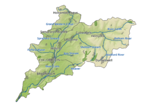
A map of the River Culm catchment target areas
The impact of nature-based solutions
Modelling natural flood management at Hele and Hemyock
This video shows a computer-based model of the River Culm catchment, predicting flooding under different rainfall and land management scenarios.
The animated model focuses on two particular locations, Lower Hele and Hemyock. Red areas show opportunities for natural flood management (NFM) in the catchment.
Flood risk is a major issue at the Hele railway crossing. The main great western railway floods regularly, thirteen times since 2008. Seven trains per hour on key routes are affected. In the baseline view we can see how the floodplain and railway crosses floods earlier than with natural flood management in place. Flooding of the track happens four hours later with natural flood management interventions, and it is possible to reopen the line four hours earlier.
Hemyock is the largest village in the Blackdown Hills Area of Outstanding Natural Beauty (AONB). Floods are short and intense with excessive surface water in the village. At particular risk are Station Road, Culmbridge Road and around Hemyock Castle. In this model we can see how flooding can be delayed through natural flood management. Also the flood peak is lower.
This animated model was created by JBA Consulting for the Connecting the Culm project.
What’s happened in the Culm catchment so far?
In 2021 and 2022 a number of nature-based solutions (NBS) demonstration sites were created and from 2023 onwards Connecting the Culm is working to establish more sites through the Devon Resilience Innovation Project (DRIP)
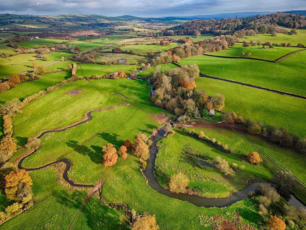
Aerial photo showing floodplain scrapes created as part of the Connecting the Culm project at the National Trust Killerton estate
Are you a landowner in the Culm catchment?
If you would like to find out more about funding available to install nature-based solutions on your land:
Get in touch via email hello@connectingtheculm.com
Or call the Culm Catchment Officer, Lucy Jefferson
Tel: 07866 212224
Lucy Jefferson
Where can I find out more?
The Flood Hub: Natural Flood Management and Riparian Owner Toolkit
Farming and Wildlife Advisory Management South West:
Soils: Devon and Cornwall Soils Alliance handbook
Environment Agency: Working with Natural Processes (WWNP)
Countryside Stewardship grants available through catchment sensitive farming link: https://catchmentbasedapproach.org/learn/catchment-sensitive-farming/